Sunday, 14 August 2011

Nathia Gali in Murree

 Nathia Gali or Nathiagali (Pashto: نتھیا گلی, Urdu: نتھیا گلی) is a mountain resort town or hill station in Hazara, Khyber Pakhtunkhwa, Pakistan. It is a part of the Galiaath which are termed such due to several hill-stations in that area ending with the word "gali", most of which are connected to one other. Nathiagali is known for its scenic beauty, hiking tracks and pleasant weather, which is much cooler than the rest of the Galiaath due to it being at a greater altitude. It is situated one hour's drive away from both Murree and Abbottabad, it lies midway between the two. Drive time from Islamabad is usually about two hours, unless there is a lot of traffic                          

Notable visitors

Nathiagali also serves as the holiday home of several prominent Pakistani families. Some of these families have been frequenting the Galiaath for 5 decades and own mountain properties and lodges there. These families tend to socialise together on an annual basis often holding barbecues, bonfires, games nights, sing-a-longs and trekking parties etc. Some of the more frequent families also give back to the local community, they have helped in renovation of the local church and mosque, and can be seen helping out at the local schools in the summer months. There are several
properties leased by multinationals and other organisations as holiday homes for their executives.

Wildlife

The Nathiagali region serves as home to all kinds of wildlife; various species of birds, insects, butterflies and animals. Unlike the crows of the southern cities of Pakistan, you will find ravens in areas like Nathiagali. Visitors are advised to sun their bedding on arrival to get rid of bed-bugs, and to keep repellants and pesticides for insects as these have a tendency to show up a lot, especially in old homes, and in the monsoon season.
Horses are a common sight during summer months and are offered to children and adults alike for rides at rates that are often negotiable. Monkeys are aplenty, previously known to be a little shy, they have reportedly become more aggressive in recent years, some say this due to increased abuse suffered at the hands of tourists, who often tease these monkeys or try to steal them. Monkeys often come up to guesthouses and hotels in search of snacks and can be quite noisy and playful.
The World Wildlife Federation has an office in the Galiaath, in recent years, this organisation assisted in the breeding of a certain type of leopard in the Black Forest right by Dungagali and Nathiagali, this area was thought to be a perfect habitat for such creatures, but according to local reports they frequently come out of the forest to steal cattle of local villagers. One such cat had to be shot. Packs of pie-dogs which were previously considered to be a night-time menace can no longer be seen anywhere in the Galiaath, it is thought that most have been killed and consumed by the newly bred leopards. In the summer of 2006, a large number of women were found dead in the deep valleys of Galiath with wounds showing that they were killed, soon, a large leopard was caught which was believed to be the culprit of all cases, he was kept in captivity but was eventually shot as a result of his aggression, his body has been stuffed and kept in the Dhunga Gali Wildlife Museum, the museum owners named him the Ghost of Galiath. These leopards are rarely spotted. However, a pet dog or animal is very likely to be grabbed by the cats at night, and if any such pets are brought to Nathiagali they must be kept indoors to avoid this.

History

During British rule Nathia Gali, then part of Abbottabad tehsil of Hazara District, served as the summer head-quarters of the Chief Commissioner. The town along with Dunga Gali constituted a notified area under the Punjab Municipalities Act, 1891. The income in 1903-4 was Rs. 3,000, chiefly derived from a house tax, whilst expenditure was Rs. 1,900.

Tourism

Nathia Gali town also serves as the administrative centre of Nathia Gali Union Council. It is located in Abbottabad District, Khyber Pakhtunkhwa. At 2,500 m (8,200 ft), it is a popular tourist resort in the summer months. It is forested with pine,cedar,oak walnut and also oak and maple trees.
During the summer, Nathiagali is relatively popular amongst tourists, but due to its limited size and availability of property, it is not thronged by as many people as the hill-station Murree, which is only an hour away.but nathiagali is to much peaceful and attractive for tourists regardng its beauty as compare to murree.
Accommodations are excellent in Nathiagali; hotels and resorts provide excellent quality accommodations equipped with all facilities. The most popular hotels are Green Retreat, Elites Hotel, Amore Hotel and many other hotels and rest houses. In summer their rates become very high.

Scenery

The natural scenery is highly magnificent. It is actually famous for it scenic beauty, the lush green meadows, deep forests of oak, cedar and pine, fog in July/August present a glory. In winter snowfall makes scene more attractive and beautiful. The church in Nathi Gali is a remnant from the period of British Government, it is totally made of wood. It is situated at the edge of the mountain from which there is a beautiful sight. Kashmir can be seen right behind this church, and is a wonderful scene.
Nathi Gali has a mini bazzar. The nearest place to Nathi Gali is Kala Bagh. Mukshpuri and Miranjani are two nearby high peaks. Both peaks are highly beautiful and present natural beauty. Taj Mahal hotel is also located in Nathia Gali.


Faisalabad


 The city was founded by the British Governor General To Punjab Sir James Loyal for whom it was originally named Lyallpur. Prior to the British making the area into an urban center, it largely consisted of various villages. However, the construction of various canals allowed the area to be irrigated. After the founding of the city, people were invited to the city with promises of land if they were to work it. This allowed the city to grow rapidly. In 1977 city was renamed Faisalabad in honor of King Faisal of Saudi Arabia who had been assassinated.

The city of Lyallpur , multicolored jewel of the lower Chenab organization area, came into being in 1880. The city which is now well known as "Manchester of Pakistan" for its industrial activity, was nothing but a desolate tract of land 100 years age. It did not rain here for weeks together and when it rained, the water vanished in the city land in no time. There was no village nearby.

In 1895, the rail link between Wazirabad and Layallpur was effected. The building of Railway Station wanted time, therefore, a Goods train wagon served as Lyallpur Railway Station. As the progress ol colonization stepped up the Lyallpur was given the status of Tehsil of District Jhang and its administration carried on the tents on the old Theh of Pucca Mari near Tariqabad.The Majestic Clock Tower of Lyallpur was constructed out of the funds raised by the Zamindars who collected it at a rate of Rs. 18 per square of land. The fund thus raised was handed over to the Municipal Committee which got it completed.

In 1902, the population of the town had exceeded 4,000. A considerable number of houses and shops to cater to the ordinary needs of the population had constructed.

In 1903, decision to have an agricultural college was made. In the very next year, 1904, the new district of Lyallpur was constituted comparing of Tehsils of Lyallpur, Samundri and Toba-Tek-Singh with a subtehsil at Jaranwala which later turned into a full fledged Tehsil.

In 1906, the District Headquarters began to function at Lyallpur and all the bazars and mohallas within the bounds of circular road were nearing completion and city began to spread outside the circular road. The Town Committee which has come into being in 1904, was upgraded as Municipal Committee in 1909 and Deputy Commissioner was declared to be the lst Chairman.In 1916, the grain market saw its shops surging with customers. In the same year the civil Hospital was expanded. With the advent of the world war II, the political awakening sprinkled its influence over the city. Revolutionary meetings were held. Fiery speeches were made. slogans were written on the walls.

In 1943, the late Quaid-e-Azam came to Lyallpur and addressed a gathering of over 2 lakh in Dhobi Ghat Grounds. And, on March 3, 1947, when Pakistan was accepted as an independent unit, the Muslims of Lyallpur held special prayers and distributed sweets and food among the poor.


After Independence


After the independence, the city of Lyallpur marched rapidly on the path of progress. The city which had so far been known for its grain market, became a great commercial and industrial centre. The population of the city which is in 1901 hardly touched the figure of a few thousands soared up to lacks. Medical and educational level was lifted up. In 1977, the name of the city was changed to Faisalabad, after the name of the late king of Saudi Arabia, Shah Faisal-bin-Abdul Aziz. In 1985, the city was upgraded as a division with the districts of Faisalabad, Jhang and Toba-Tek Singh.

LOCATION Faisalabad is called Manchester of Pakistan. It is having a lot of Textile and other mills. It is famous for its eight bazaars. Faisalabad is an industrial city of Pakistan, Situated 225-miles (360 kilometers) south of the capital Islamabad. The district lies from 30-35 to 31-47 north Latitudes and 72-73 to 73-40 east longitudes. Gujranwala And Sheikhupura districts bound it in the north. In the East by Sheikhupura and sahiwal districts. In the south By Sahiwal and Toba tek singh districts and jhang. District is to its west. The city covers an area of 5,856 Square kilometers. The city is linked to m-2 motorway (Islamabad-Lahore motorway) with m-3 motorway section (Pindi-Bhattian-Faisalabad motorway). Faisalabad (Formerly Lyallpur) is a road and railway junction, which lies in an area watered by the Lower Chenab Canal. Cotton, wheat, vegetables, and fruits are grown there and the city is also an industrial centre with railway-repair yards, engineering works, and mills that process sugars, flour, and oil seed. Produce includes super phosphates, cotton and silk textiles, hosiery, dyes, agricultural equipment, and ghee (clarified butter). Faisalabad is the site of the University of Agriculture, founded in 1909.

Literature: Nusrat Fateh Ali khan, the famous singer And musician born in this city; Afzal Cheema, the former Chief justice of Lahore high court also belong to this City.

Art: the famous clock tower of Faisalabad has 8 Streets leading from it and was designed in a pattern so As to form union jack.

Cinemas:Faisalabad district has twenty-four cinemas, With a total seating capacity of 16,688. It provides an Entertainment towards its residents by showing Urdu, Punjabi and English movies.

DRYPORT: Faisalabad has established a dry port, which Presently handles over 60 metric tons of cargo per day. The port has its own road and railroad links with Lahore, Islamabad, Peshawar and Karachi. The export Cargo at Faisalabad dry port is increasing every year. According to the Faisalabad dry port trust, it Handled l7,468 export cargo containers, worth Rs.28,600 Million during the first 10 month of the current Calendar year. DP provided lucrative Incentives to the exporters of Faisalabad and offered Certain concessions in fdpt tariff to the importers. It Handled 1,847 import cargo containers during the same Period, worth Rs. 1,500 million Faisalabad.

GULISTAN COLONY: One of the most prominent places of Faisalabad is Gulistan Colony which is one of the oldest colony of the Faisalabad bearing outstanding environment and is the nearest approach to top facilities including Motor way. http://funaziz.blogspot.com/

Lahore City

 Lahore is the capital of the Pakistan province of Punjab and the second largest city in Pakistan, after Karachi. The Lahore city lies along the Ravi River, situated approximately 25 kilometres (16 mi) from Wagah border crossing and is 32 kilometres (20 mi) from the Indian city of Amritsar.

Historically, Lahore has been a center of cultural heritage for many civilizations. Lahore successively served as regional capital of the empires of the Shahi kingdoms in the 11th century, the Ghaznavids in the 12th century, the Ghurid State in the 12th and 13th century, the Mughal Empire in the 16th century, the Sikh Empire in the early 19th century, and it was the capital of the Punjab region under the British Raj in the mid 19th and early 20th century. The traditional capital of Punjab for a thousand years, Lahore was the cultural center of Northern India extending from Peshawar to New Delhi.[16] Mughal structures such as the Badshahi Mosque, the Lahore Fort, Shalimar Gardens, and the mausolea of Jehangir and Nur Jehan are popular tourist attractions for the city. The population of lahore is approximately 10 million

Other attractive places of Lahore

Lahore Zoo
Established in 1872, was once considered one of the largest zoos in Asia.

The Mall
Historically a key city road, has many buildings from Mughal era and British Rule.

Walled City
Also known as the Old City, is the section of Lahore that was fortified by a city wall during the Mughal era. The wall had 13 gates, and much of the wall remains intact today.

Data Durbar
Complex where Hazrat Syed Abul Hassan ibn Usman ibn Ali Al-Hajweri, the famous Sufi saint of South Asia, is buried. Complex includes Hajveri Mosque, built in pre-Mughal era.

Chauburji
Chauburji has remains of an extensive garden known to have existed in Mughal times. Today, Chauburji is also known for its big bustling markets.

Hiran Minar
Just north of Sheikhupura town (on the outskirts of Lahore) lies a hunting complex known as the Hiran Minar. Hunting grounds were an important part of the physical environment of Mughal emperors, and the Hiran Minar is one of the best known and most beautiful of such sites. Its structures consist of a large, almost-square water tank with an octagonal pavilion in its center, built during the reign of Shah Jahan; a causeway with its own gateway connects the pavilion with the mainland and a 100-foot-high minar, or minaret. At the center of each side of the tank, a brick ramp slopes down to the water, providing access for royal animals and wild game. The minar itself was built by Emperor Jahangir in 1606 to honor the memory of a pet hunting antelope named Mansraj.


Patriata


 Patriata is a quiet retreat at the highest point of Murree Hills which consequently is the highest point of Punjab as well. Patriata has a breathtaking landscape.

Patriata is a quiet retreat at the highest point of Murree Hills which consequently is the highest point of Punjab as well. Patriata has a breathtaking landscape. High forested ridges and deep intersecting valleys with terraced slopes offer magnificent views of this naturally beautiful area. http://funaziz.blogspot.com/


Mohenjo-daro


When looking for something in Pakistan that will appeal to the history nut in you, there is no other place that can beat Mohenjo-daro. Located in the ancient Sind Province, Mohenjo-daro is geographically in the southern portion of the country. It was one of the most prosperous cities of the Indus civilization, owing partially to its location on the Indus River’s right bank. This UNESCO World Heritage Site was established at least 4000 years ago. The city, which used to measure around one square mile, easily became a hub of the civilization in the Indus Valley. At that time, it was one of the earliest human settlements anywhere in the world and one of the most planned cities. During its ancient heyday, around 500 people lived in Mohenjo-daro.

The ancient city was then divided into two portions – the Citadel and the lower city. In the Citadel, there was a public bath with elaborate brickwork decorating it and an advanced drainage system. An imposing veranda used to surround this part of the city. The lower city, meanwhile hosted a granary, residences and assembly halls. The streets were planned in a precise manner, with straight orientation and connecting all parts of the city.

The city suffered devastation when the Indus River changed its course. The whole civilization was submerged and after centuries, the ruins of what used to be a glorious city remains, attracting tourists from all around the globe. In 1922, it was rediscovered and excavated by an officer of India’s Archeological Society. If you have the chance to visit the place, you can marvel at the ruins that have though time been carefully reconstructed. Unfortunately, part of the city has been losing a lot of important archeological artifacts due to looting and illegal acts. A visit to the site’s museum will also provide fascinating insight into this city’s history.

Hanna Lake

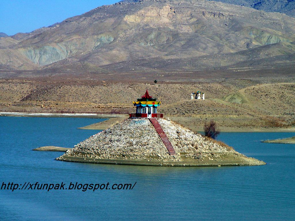
 Hanna Lake a delightful picnic spot near Quetta city in Pakistan and is one of the main attractions in the city. The lake is located a little short of the place where the Urak Valley begins and 10 km from Quetta. The greenish-blue waters of the lake provide a rich contrast to the sandy brown of the hills in the background.

Golden fish in the lake comes swimming right up to the edge of the lake. There is a lakeside restaurant with picnic tables shaded by pine trees. At one end, the irrigation dam rises out of the depths like battlements of a fort. http://funaziz.blogspot.com/


Gwadar

 Gwadar is a developing port city in Balochistan, Pakistan. Gwadar is strategically located between three increasingly important regions: the oil-rich Middle East, heavily populated South Asia and the economically emerging and resource-laden region of Central Asia. Gwadar is the location of the Gwadar Port, a warm-water, deep sea port. China has acknowledged that Gwadar’s strategic value is no less than that of the Karakoram Highway, which helped cement the China-Pakistan relationship. Beijing is also interested in turning it into an energy-transport hub by building an oil pipeline from Gwadar into China's Xinjiang region. The planned pipeline will carry crude oil sourced from Arab and African states. Gwadar is located on the Gulf of Oman close to the entrance of the Persian Gulf, about 460 kilometres west of Karachi. In 1993, Pakistan started feasibility studies for the development of a major deepwater seaport at Gwadar. The port project commenced on 22 March 2002 with the first phase completed in December 2005. The Civil Aviation Authority of Pakistan has earmarked 3000 acres (12 km²) of land for Gwadar International Airport which will be built 26 km away to the northeast of the existing airport towards Pasni and is likely to cost between $200–250 million. The new airport will be given international status and operate under the open sky policy. In the meantime there are plans to improve facilities at the existing airport. The Gwadar deep-sea port emerges as a place of great strategic value, enhancing Pakistan's importance in the whole region, extending from the Persian Gulf through the Indian Ocean to Southeast Asia and the Far East.
The government of pakistan declared Gwadar port a "Special Economic Zone" in the budget, 2003-2004. All banks will open their branches, five star hotels will be built, offshore banking will be started, factories, warehouses and storage will be set up, the tourism industry will be promoted in the area, an export processing zone will be set up, making Pakistan a very attractive place for direct foreign investment, and Gwadar port a regional hub of trade and investment activities.
Oman has offered $100 million aid for the development of social and infrastructure facilities in Balochistan. Out of $100million, Oman has provided $7million for extending of runway at Gwadar Airport, construction of jetties, upgradation of Gwadar Hospital, provision of 100 engines to fishermen and construction of power house. Oman is also financing construction of Gwadar-Hoshab Road, water supply scheme in Gwadar area and construction of irrigation dams. http://funaziz.blogspot.com/